The Viewer Interface | The Toolbar | Analysis Tab

Analysis Tab

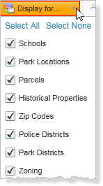
The Analysis tab of the toolbar contains tools to help you find information as well as measure, manipulate, and analyze data.

Analysis tab of the toolbar

The tools in this tab are grouped into these sections:

Use this tool... To...

Identify data at a particular point anywhere on the map. All the features beneath the point you click are listed in the Results List.

Identify features by drawing a line in any direction on the map. All the features that intersect with the line you draw are listed in the Results List.

Identify features by dragging a line in any direction on the map. All the features that intersect with the line you draw are listed in the Results List.

Identify features by drawing a segmented shape over an area on the map. All the features beneath the shape you draw are listed in the Results List.
Identify features by drawing a rectangle over an area on the map. All the features beneath the shape you draw are listed in the Results List.
Define the layers to include or exclude in the identify process.
Add a measured area around each area you identify.
Measure distances on the map by drawing a segmented line.
Measure an area of the map by drawing a shape.
Add the distance or area measurement to the map as a drawing.
Erase a drawing by clicking it.
Clear all the drawings on the current map.
Shows the final measurement of a drawing. This graphic is indicating the perimeter length and area of a polygon.

Change the unit of measurement on a drawing to other options like Yards, Meters, Nautical Miles etc.

Select a coordinate system and then enter known coordinates to find a feature. You choose whether to add the coordinate to the map as a callout. You can also choose to pan to that coordinate when you click OK.

Place a callout on the map for every point you click.
Clear any coordinates currently on the map.

Find the coordinates by clicking anywhere on the map and reading the result in this box. If you click the Plot Coordinates tool and then click the map, the coordinates for each place you click appear on the map.

Select a different Coordinate System.

See also...

Use the Identify Tools

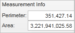
Measure Distance and Area on the Map

Online Help © 2013 Latitude Geographics Group Ltd. All Rights Reserved.